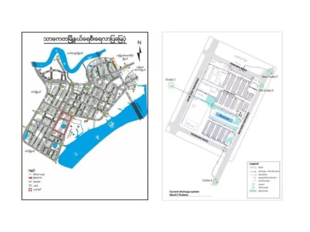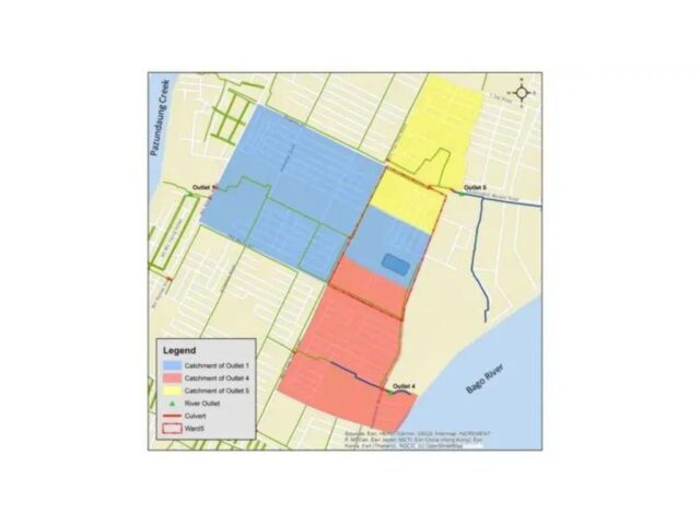
The existing situation in Ward 5 is that flooding takes place in various locations in the ward, mostly when heavy rain and high tide coincide. This flooding has several causes:
- The current drainage system is not fully functioning (due to no proper maintenance, accumulation of waste and/or accumulation of sedimentation)
- The current drainage system is not suitable for heavy rain events. This can have several aspects – all of them are, to a certain extent, the case in ward 5:
- The outlet capacity is not large enough
- The outlet is not always functioning due to tidal influences (see explanation here)
- The network of drains and the dimensions of the drains are not sufficient to cope with a lot of water (both capacity of the network as technical design, e.g. culverts with proper size and level, levelling of the drains towards the river)
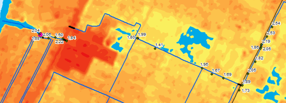
The above mentioned issues can be improved with a set of measurements, ranging from improving waste management, regular maintenance and upgrading of the drainage system. However, due to the topographic and demographic characteristics of Thaketa even with a fully functioning drainage system, it will be a challenge to get rid of all the water during a heavy rain and with high water levels in the river. The neighbourhood is a dense built-up area and is in general low-lying and flat, surrounded by rivers with fluctuating water levels.
The above means that next to improving the drainage system itself and the overall functioning, we should also think about ways to increase the buffer capacity in Ward 5, to increase resilience towards flooding. Possible interventions are:
- Increase the buffer capacity within the drainage system, by making the drains wider and/or deeper than strictly necessary (important note: the drains should not be too deep, as it still needs to be able to flow towards the outlet).
- Create separate buffer areas to temporarily store water; this water can then slowly infiltrate into the soil, and/or flow into the drainage system when there is enough capacity again
- Create a bioretention/ wetland: large areas that can temporarily store water, with fluctuating water levels and vegetation that is able to clean the water
- Increasing the capacity of the existing retention lake, e.g. through higher dykes.
- Store rainwater in rainwater barrels or (underground) rainwater storage tanks
Possible impacts
The table below lists the different types of impact the several options for buffering have:
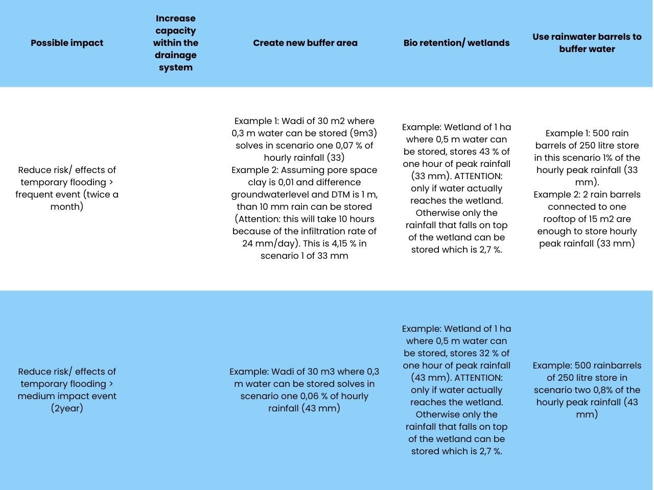
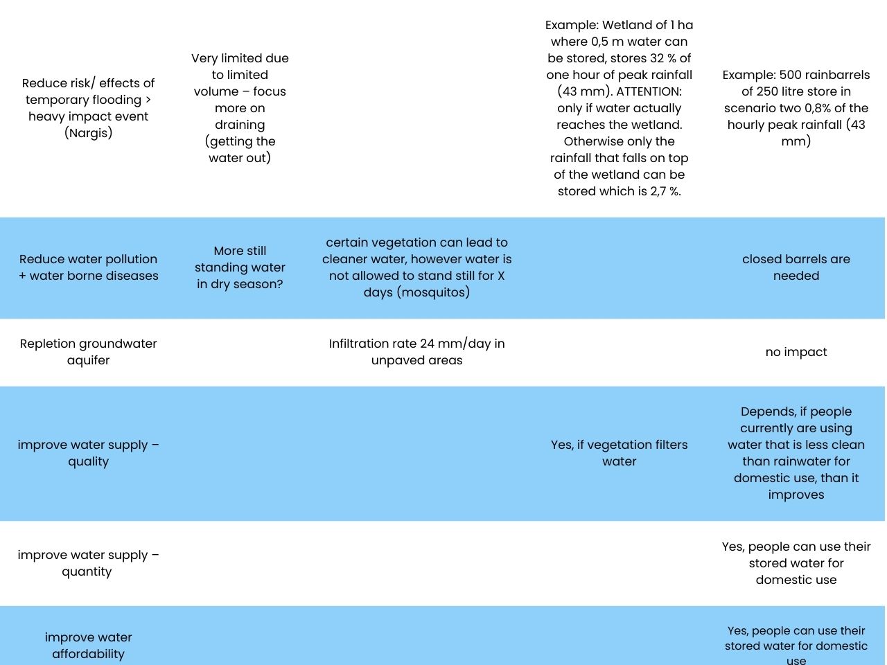
| Possible impact | Increase capacity within the drainage system | Create new buffer area | Bio retention/ wetlands | Use rainwater barrels to buffer water |
|---|---|---|---|---|
| Reduce risk/ effects of temporary flooding > frequent event (twice a month) | Example 1: Wadi of 30 m2 where 0,3 m water can be stored (9m3) solves in scenario one 0,07 % of hourly rainfall (33) Example 2: Assuming pore space clay is 0,01 and difference groundwaterlevel and DTM is 1 m, than 10 mm rain can be stored (Attention: this will take 10 hours because of the infiltration rate of 24 mm/day). This is 4,15 % in scenario 1 of 33 mm |
Example: Wetland of 1 ha where 0,5 m water can be stored, stores 43 % of one hour of peak rainfall (33 mm). ATTENTION: only if water actually reaches the wetland. Otherwise only the rainfall that falls on top of the wetland can be stored which is 2,7 %. | Example 1: 500 rain barrels of 250 litre store in this scenario 1% of the hourly peak rainfall (33 mm). Example 2: 2 rain barrels connected to one rooftop of 15 m2 are enough to store hourly peak rainfall (33 mm) |
|
| Reduce risk/ effects of temporary flooding > medium impact event (2year) | Example: Wadi of 30 m3 where 0,3 m water can be stored solves in scenario one 0,06 % of hourly rainfall (43 mm) | Example: Wetland of 1 ha where 0,5 m water can be stored, stores 32 % of one hour of peak rainfall (43 mm). ATTENTION: only if water actually reaches the wetland. Otherwise only the rainfall that falls on top of the wetland can be stored which is 2,7 %. | Example: 500 rainbarrels of 250 litre store in scenario two 0,8% of the hourly peak rainfall (43 mm) | |
| Reduce risk/ effects of temporary flooding > heavy impact event (Nargis) | Very limited due to limited volume – focus more on draining (getting the water out) | Example: Wetland of 1 ha where 0,5 m water can be stored, stores 32 % of one hour of peak rainfall (43 mm). ATTENTION: only if water actually reaches the wetland. Otherwise only the rainfall that falls on top of the wetland can be stored which is 2,7 %. | Example: 500 rainbarrels of 250 litre store in scenario two 0,8% of the hourly peak rainfall (43 mm) | |
| Reduce water pollution + water borne diseases | More still standing water in dry season? | certain vegetation can lead to cleaner water, however water is not allowed to stand still for X days (mosquitos) | closed barrels are needed | |
| Repletion groundwater aquifer | Infiltration rate 24 mm/day in unpaved areas | no impact | ||
| improve water supply – quality | Yes, if vegetation filters water | Depends, if people currently are using water that is less clean than rainwater for domestic use, than it improves | ||
| improve water supply – quantity | Yes, people can use their stored water for domestic use | |||
| improve water affordability | Yes, people can use their stored water for domestic use |
Multi-Criteria Analysis
After developing a final ‘toolbox’ to work with we conducted a so-called ‘Multi-Criteria Analysis’ – where all selected interventions are graded between 1 to 5 in terms of impact. In the table below the general impact is shown:
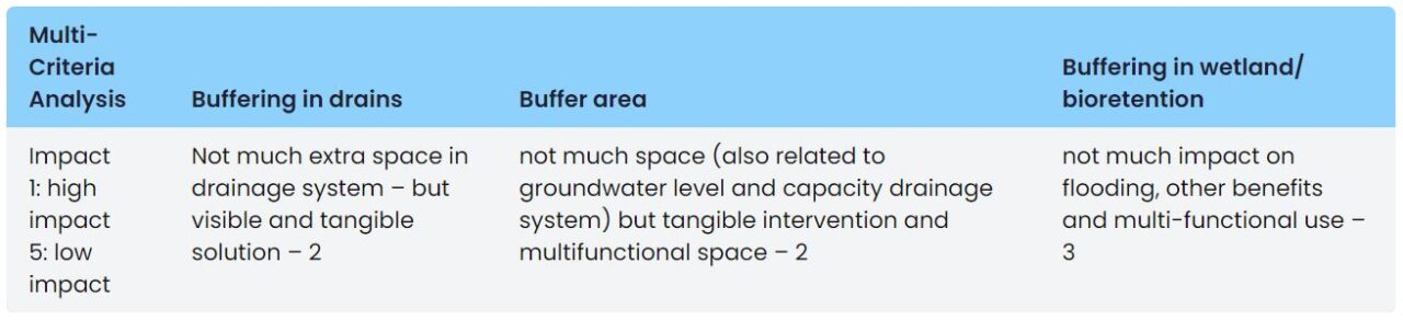
| Multi-Criteria Analysis | Buffering in drains | Buffer area | Buffering in wetland/ bioretention |
|---|---|---|---|
| Impact 1: high impact 5: low impact |
Not much extra space in drainage system – but visible and tangible solution – 2 | not much space (also related to groundwater level and capacity drainage system) but tangible intervention and multifunctional space – 2 | not much impact on flooding, other benefits and multi-functional use – 3 |
For this project, we decided to work on a design for a new buffer area in the Ward. Unfortunately we were not able to fully finalize the design and work towards implementation, due to the circumstances in Myanmar during the project. The design therefore is mostly a theoretical exercise, based on some fieldwork, an analysis of the current drainage system and the use of a model of the drainage system (SOBEK).