As part of the Thaketa Climate Resilient project, one of the aims is to improve the drainage system of Thaketa Ward 5 and decrease the impact of flooding on its residents. To do this, we need to fully understand how the current drainage system is working within ward 5.
During the first phase of the project, we gathered information through engagement with the ward officer, YCDC and residents on the existing drainage systems within the Thaketa township as well as of Ward 5. In the second phase, we did a measurement campaign to gather quantitative data on the drainage system.
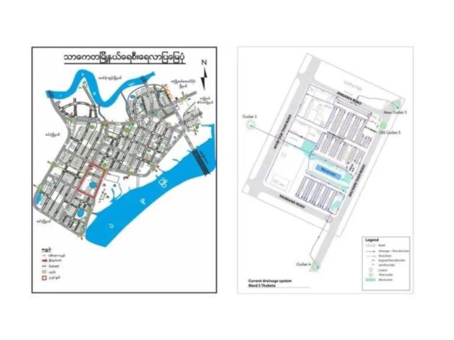
For a description of the drainage system of ward 5, please see here.
Drainage Level Measurement Campaign
The levelling measurement campaign was carried out to investigate the actual conditions of the drains (front drains as well as alley drains), culverts, river outlets and their flow directions. We also measured the alley drains that the project team improved and fixed before the monsoon season. The measuring components include road level, bed level, water level and width of the drains, culverts and outlets.
Aim and Objectives
The main aim is to make ward 5 a climate-resilient neighbourhood in terms of flood risk reduction by improving the drainage systems both within and outside of the ward. The specific objectives of this measurement campaign are as follows;
- To check the slope of the drains within ward 5, to understand if a correct flow of the water is possible
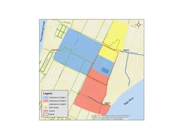
- To check the slope of the drains towards outlets 1 and 4 as above
- To gather data for modelling and understanding the bottlenecks
- Bed levels of drains, culverts, outlets (link to junction points in the model), together with water level measurements
- To support future works for the project team and Ward Officer/ YCDC
Methodology Approach
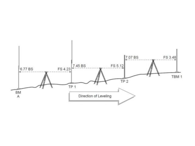
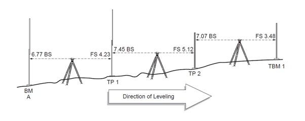
For the measurement campaign, a differential levelling method is used to reach the desired outcomes.
Some important terminology
Levelling: The process of finding the elevation at a specified location relative to another known elevation.
Differential levelling: Among the different levelling methods, differential levelling is the most common method used to determine differences in elevation. A horizontal line of sight is established and readings are made using a telescope and graduated rods
Basic theory:
- Add rod readings to the elevation of the benchmark to get the elevation of the line of sight
- Subtract rod readings from the elevation of the line of sight to establish the elevation of unknown points
BenchMark (BM): A permanent object that has a known height above mean sea level (or another reference datum) that is provided by the Department of Survey and Mapping.
Temporary Bench Mark (TBM): A moveable object that has a known height above a predefined level. This level is not absolute and is defined locally by the surveyors for the survey. Based on the TBM the survey may then later be reduced to absolute levels if the level of TBM is known.
Height of Instrument (HI): The elevation of the line of sight established by the instrument.
Backsight (BS): The reading on the rod when held on a known or assumed elevation. Backsights are used to establish the height of the instrument. A sighting with a level back to a point of known elevation.
Foresight (FS): The reading on the rod when held at a location where the elevation is to be determined. Foresights are used to establish the elevation at another location, often a turning point. A sighting with a level to determine the elevation of a point.
Intermediate Foresight (IFS): The reading on the rod when held at a location where the elevation is to be determined but not used as a turning point. A foresight to a point at which you want to know the elevation but which will not be used as a turning point
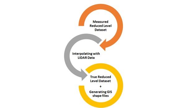
Reduced Level(RL): The vertical distance measured above or below the mean sea level or benchmark is called a reduced level.
Datum: Any level surface to which elevations are referenced.
Assumed Datum: This is established by giving a temporary benchmark an assumed value to which all levels in the local area will be reduced. It is not good practice to assume a level that is close to the actual MSL value, as it creates a potential for confusion
Change/Transfer Point (CP/TP): It is a point on which fore-sights and back-sight are taken.